

Rezoning in 1980s & West Dallas
Citywide Rezoning and West Dallas
Prior to 2006, past plans for this area highlighted the need for industrial and residential uses to be appropriately buffered, and when adjacent for the industrial districts to be removed. The City had the opportunity to rezone the residential homes in and adjacent to the industrial zoning and industrial uses in a matter consistent with residential uses during the 1980s. In July of 1984, the City of Dallas adopted a set of planning policies that called for writing a new zoning code for the entire City. The purposes for the change, among others, included the stabilization of neighborhoods and the improvement of the quality of life in Dallas. The 1984 planning policies required the protection of residential neighborhoods from intrusive and destabilizing effects of industrial and other non-residential uses. The City Council adopted the new zoning code and the program for the transition to the new zoning code on July 22, 1987.
These benefits however, were not extended to West Dallas or to other communities of color, such as Cadillac Heights. In a lawsuit on behalf of residents in Cadillac Heights, Judge Fitzwater, a federal district court judge, quoted the defendants evidence on the inequitable race of persons living in or near industrial zoning in that case against the City of Dallas in the opinion and of the City’s 1980s zoning changes. (Miller v. City of Dallas, 2002 WL 230834 (N.D. Tex. 2002).)
According to 1990 statistics, African-Americans constituted 47.25% of the Dallas population living in Census blocks that were either within an industrial-zoned district or within five hundred feet of one. Id. at 1901. Hispanics constituted 28.36% of the Dallas population living in such blocks. Id. But as of 1990, the overall population of Dallas was 28.89% African-American, 20.88% Hispanic, and 50.23% other. Id. at 1774.
In 1984 the City Council adopted the “City of Dallas Planning Policies,” which include the goal that “[e]ach neighborhood of the City shall be protected and/or improved so as to be a desirable and attractive residential neighborhood.” Id. at 13. The same document states the City’s objective “[t]o reduce the uncertainty of each neighborhood’s future in order to attract more private maintenance, reinvestment and new investment.” Id. By deliberately denying flood protection to Cadillac Heights, allegedly because there is developable land that lies outside the flood plain and therefore does not need such protection, plaintiffs can make a reasonable argument that the City departed from its standards of protecting neighborhoods and reducing uncertainty in order to attract residential development, maintenance, and investment.
(Miller v. City of Dallas, 2002 WL 230834 (N.D. Tex. 2002).)
The City of Dallas Zoning Transition program and the map below show the general transition policies. For industrial uses, the transition process was made dependent on the type of “transition policy area” in which the industrial uses were located. The City defined the location of the “transition policy areas” on maps. There were four transition policy areas for industrial uses:
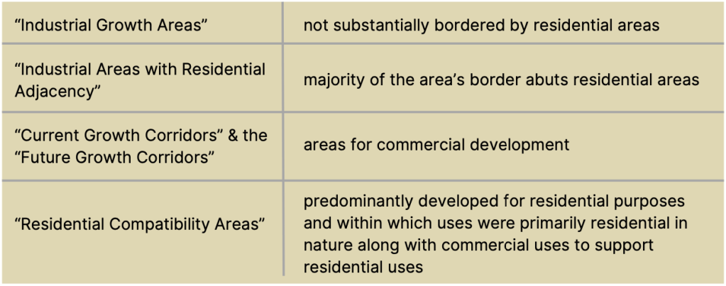
At that time, there were two types of industrial zoned districts in West Dallas. I-3 was the heaviest industrial use and I-2 was the next. The equivalent industrial zoning categories under the new zoning structure were IM (Industrial Manufacturing) and IR (Industrial Research). These are the categories in place today. The determining factor whether property zoned I-3 or I-2 could be changed under the transition program to the equivalent IM or IR zoning was the transitional policy area of the location.
Under the transition policy, I-3 could transition to IM as a matter of right in Current Growth Corridors, Future Growth Corridors, and Industrial Growth Areas. I-2 could transition to IR as a matter of right in Current Growth Corridors, Future Growth Corridors, and Industrial Growth Areas and to IM in Future Growth Corridors or Industrial Growth Areas. But, in Industrial Areas with Residential Adjacency, I-3 and I-2 zoned property could transition only to Light Industrial or Commercial Services. Property zoned I-3 or I-2 could transition only to Commercial Services zoning in Residential Compatibility Areas.
The Singleton area was considered an Industrial Growth Area according to the Zoning Transition Program of 1987, though it was also classified as a “Special Study Area”. There is a land plan listed for West Dallas- “West Dallas Economic Development & Neighborhood Preservation Plan (1983)” that goes into depth about the zoning and land use of this specific area and indicates the mislabeling of the Singleton area as Industrial Growth due to its residential adjacency. In essence, it was known in 1983 that the area surrounding GAF should not have been labeled ‘Industrial Growth’ and in 1987 that error was never rectified. Had it been, GAF would only have been able to operate as light industry or a commercial service. Not be operating as an Industrial Manufacturer as it is today.
West Dallas Strategy Economic Development & Neighborhood Revitalization 1983

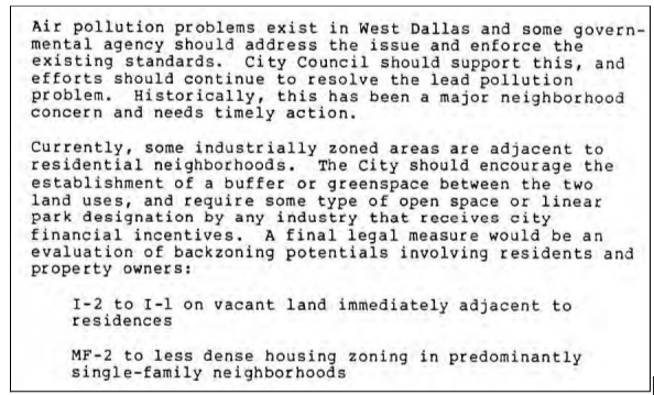
This plan was drafted to encourage economic development and neighborhood revitalization in West Dallas. The map below shows the various sub areas with different policy recommendations. The GAF area was designated as “Development Area 2”. The proposed land use for Development Area 2 is outlined below as taken from the plan. “Backzoning” (also commonly called “downzoning”) is meant to reduce the intensity or heaviness of the zoning to be less industrial (i.e. from I-3 heaviest to I-1 least heavy). Based on the current zoning in the same area, this never happened.
Development Area 2 is described as:
“A relatively large amount of vacant land also exists here, although some of it has environmental and topographic problems. This area should be targeted for more intense industrial use and economic development”
West Dallas Economic Development and Neighborhood Preservation Study
A more clear outline of Development Area 2 is outlined below.

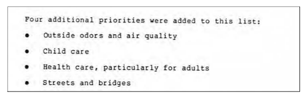
The area where GAF was referenced is Development Area 2, where “In the target area north of I-30 are well over 600 acres of vacant, industrially zoned land currently owned by a limited number of owners. This supply should meet market demand for at least 20 years. Industrial development should be directed to this vacant (infill) land, which should be appropriately buffered from housing”. This did not occur. The homes north of I-30 by the previously vacant industrial land have not benefited from neighborhood preservation, and were actually further encroached on by industry over time, reducing the buffer between homes and heavy polluters. Air pollution and the need to create buffers between residential and industrial uses was included in the study, as well as the need to downzone areas in collaboration with residents and property owners. In 1983, many priorities were identified by the participating neighborhood representatives and stakeholders. “Outside odors and air quality” was listed as one of the priority concerns.

The Land Use Guidelines throughout West Dallas are described in the 1983 plan as and is roughly interpreted in the Figure to the left:
- “In the area between Vilbig, Singleton and Canada, a backzoning of the multifamily-zoned property to a less dense residential use should be discussed with the property owners.
- In the area between Norwich, Pluto (and its extension), Singleton, and the Old Trinity River, a backzoning of the vacant industrial land to I-1 should be discussed with the property owner. However, this backzoning should be done in conjunction with some development incentives for the property.
- The vacant land south of Singleton between Westmoreland and Chalk Hill should be targeted for the more intense industrial activities that are proposed for the area”
These land uses highlight the deindustrialization (back zoning) of the vacant industrial land north of Singleton, and further east close to Downtown Dallas. The mixed industrial and residential area between Westmoreland Drive and Vilbig does not have land use guidelines outlined in this section of the 1983 plan. The study includes information about the growth potential in West Dallas with the large vacant industrial areas, in addition to the need to provide jobs for low income residents. Specifically, it cites “Some of the industries already located in West Dallas are “heavy” industries. Certain types of environmental concerns, such as air and noise pollution and traffic, are related to their presence. Future industrial development must focus on the more labor-intensive industries, particularly those that provide products and services needed in our evolving economy”.
