
Residential Community Under Attack
Character of the Neighborhood
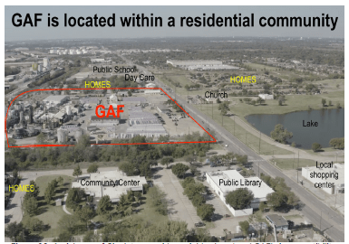
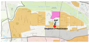
Despite the City of Dallas’ best efforts, the Singleton Corridor neighborhood continues to host many residential homes, multiple public schools and day care centers, as well as community recreation centers. The aerial view below shows the homes and public spaces immediately surrounding GAF and illustrates the size of the facility that is embedded within the heart of a residential community.
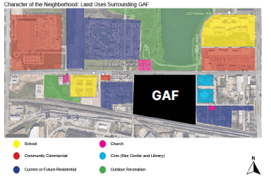
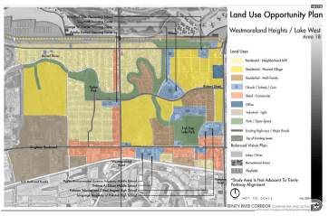
The map below illustrates the current land uses in the neighborhood and the deeply incompatible nature of the GAF facility in the context of the rapidly growing residential and commercial neighborhood.
Demographic Characteristics and Changes
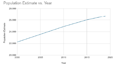
GAF is located in the heart of West Dallas, a majority residential area that was annexed into the City of Dallas in 1954 and consists of several unique neighborhoods. Prior to annexation in 1954, many residents lived in West Dallas without basic city services and amenities such as flood control, sidewalks and streets. Since then, West Dallas’ population has grown exponentially and city services, commercial development, educational institutions and access to park and green space has dramatically increased. According to the U.S. Census Bureau ACS 5-Year Estimates from 2019, West Dallas (75212) has an estimated population of 26,720.
These changes in population growth that we are seeing are in contrast to the predictions for this community outlined in the “Encouraging Economic Development in Southern Dallas Study” conducted by the City of Dallas in 1981. Specifically, the study determined that the number of residents would decrease due to industrial growth in West Dallas. Other studies also conducted in the 1980s describes future land use for the “Neighborhood West of Bernal Drive and West Dallas north of Singleton Boulevard” as: “when allowance is made for the removal of scattered housing by industrial and commercial expansion, very little population increase is anticipated in the Community. One entire residential area just to the west of the intersection of Westmoreland and Irving Boulevard is proposed to be converted to industrial use”.
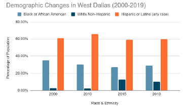
The demographic characteristics of West Dallas have also changed over time, but has consistently been a majority non-White neighborhood, with the majority of residents identifying as Hispanic or Latino.
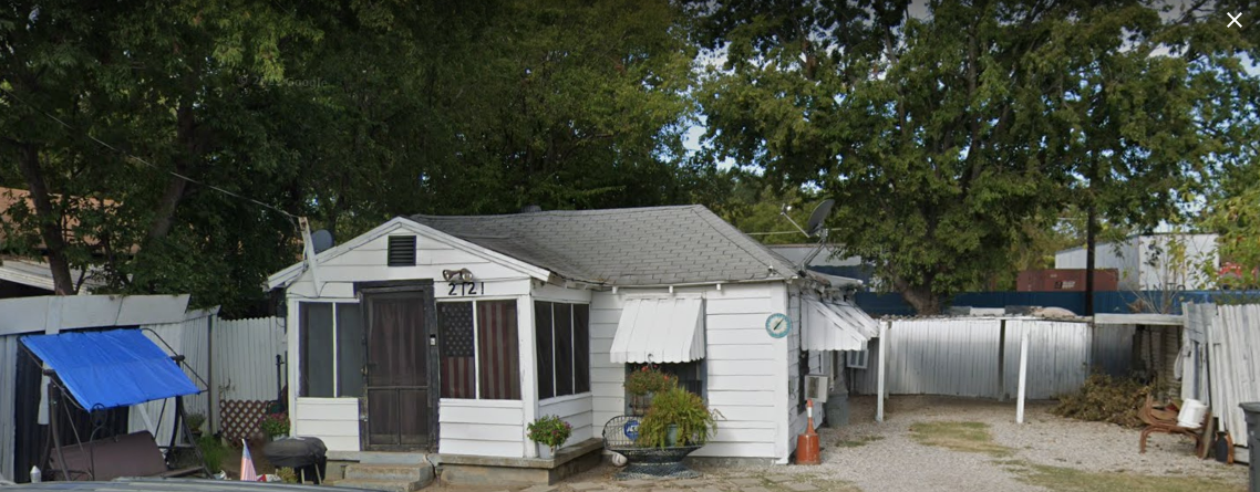
There are three residential areas that comprise the neighborhood where GAF is located: Bedford to the west, the Multipurpose Center area to the east, and Kingbridge Crossing Dallas Housing Authority homes to the north. These three areas in addition to a residential neighborhood (Muncie) further east, make up the Singleton United/Unidos neighborhood. There are several other neighborhoods in West Dallas that are within 1 mile of GAF including Ledbetter/Eagleford, Westmoreland Heights, Greenleaf Village and Victory Gardens.
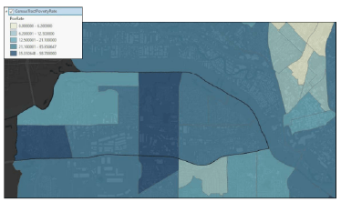
There are several census tracts within West Dallas that have varying poverty rates ranging from 35.4%-58.7% of the population in the tract where GAF is located (205) experiencing poverty, to the lowest rate in West Dallas being 6.2%-12.5% of the population in the Eagleford Ledbetter neighborhood experiencing poverty. This is considered a lower income area in the context of the City of Dallas, and the census tract where GAF is located is the lowest income area of West Dallas.
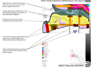
The Singleton United/Unidos neighborhood area along with other participating neighborhood associations in West Dallas drafted a land use plan specifically focused on protecting the character of the neighborhood and promoting positive development in their community. The plan specifically calls for preserving and enhancing the single family homes adjacent to GAF, increasing community recreational programming at the Multipurpose Center and Library, improving the quality and access to Fish Trap Lake, all which emphasize the incompatibility of GAF in the center of their neighborhood. The City of Dallas also highlighted the incompatibility of GAF in the neighborhood in the adopted Trinity River Corridor Plan (2006) by proposing the future land use of the site be dedicated as “Community Retail” and “Multifamily Residential”.

The area included in the proposed Authorized Hearing boundaries is demonstrated in the map to the right shaded in yellow taken from the Recommendations section of the Singleton Corridor Neighborhood-Led Plan. GAF is the red nonconforming use in the middle with the recommendation to seek amortization. Both the amortization of GAF and the Authorized Hearing of the neighborhood are necessary to further environmental justice and fair and affordable housing goals.
Next: Conclusion
